









Seagate Storage Takes Flight
Researchers at NASA-funded Montana Space Grant Consortium and Nature Conservancy power massive drone-gathered data sets with Lyve Mobile, saving environment 1TB at time
This is a Press Release edited by StorageNewsletter.com on October 28, 2021 at 2:00 pmOn the low, rolling grasslands of northern Montana, thousands of sage grouse converge every spring, strutting and burbling their calls across salty clearings in search of mates.
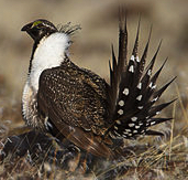
These squat, white-breasted birds vary from 2 to 7 pounds. The males puff up great yellow air sacs on their chests and fan out their spiky tails, making popping sounds in the chill mornings to intimidate their competitors.
At any given mating ground, or lek, there might be hundreds of sage grouse going about this ritual. More recently, that number may have fallen to dozens. In 2019, Montana state wildlife officials noted a 40% drop in sage grouse population over the prior 3 years. Causes may be due to human activity, climate change, natural cycles, etc. One thing ecosystem specialists know for sure is that sage grouse are an indicator species, meaning that population counts can speak an inordinate amount about the well being of an ecosystem. Stable populations indicate a healthy habitat and that the preservation methods being applied to the range by land managers and biologists are working. A population decline often signals something amiss in need of a remedy.
Without reliable population counts, conservationists have no solid data on which to base their arguments. One researcher, deep in the Montana grasslands, uses Seagate’s Lyve Mobile shuttles physical data to help improve his sage grouse analysis methods. The results of that work reach far beyond bird counts-and into the forecast of North America’s climate change.
But the story of that project doesn’t begin with strutting and leks. Instead, it begins with researchers tapping their fingers in frustrated boredom as they wait for data uploads into the cloud.
PoC
Jennifer Fowler, assistant director, Montana Space Grant Consortium (MSGC), a NASA higher education program, and director of the University of Montana’s Autonomous Aerial Systems Office (AASO), is long on field work experience and short on time. She’s helping develop a system for using drones to gather wildfire data, such as imagery for determining rate of spread. The faster data can be gathered and analyzed, the sooner results can be used to help combat the blaze, guide evacuations, and direct emergency services resources.
That outcome lies in the future, though. First comes methodology development and modeling, so Fowler and her team regularly gather data sets from the US Forest Service and use those terabytes to fuel real-time simulations. Usually, the university manages its data transfers and sharing through a public cloud service, but the wildfire project’s dataset currently stands at over 120TB, and each fire event generates another 12TB to 14TB. Such massive volumes make cloud uploading and downloading almost entirely impractical. Workers can be found sitting at the Forest Service office for countless hours, waiting for the latest dataset to upload into the university’s cloud account.
Frustration led to an inevitable conclusion: There was no way to develop a practical real-time analysis workflow with cloud storage between the data source and the analysis team.
In September of 2020, the need for a better solution ratcheted higher when Fowler’s team received a high-resolution hyperspectral camera. The quality and breadth of data improved, but the camera generated roughly 7GB per day, constricting their potential data transfer bottleneck even tighter.
In serious need of a solution, Fowler procured a Lyve Mobile shuttle-and everything changed.
The 16TB external HDD came equipped with both USB-C and 10GbE ports. It also featured Seagate Secure AES-based encryption. Along with Forest Service data that sometimes requires end-to-end safeguarding along with data for subsequent projects, full encryption would ensure military-grade data protection for all in-transit information.
“We started putting everything on Lyve Mobile shuttles,” says Fowler. “Once loaded in the field, it was easy to bring back into our office, plug in to our network, and instantly make it accessible to the team.“
Lyve Mobile shuttles handled the organization’s large data loads, transferring them quickly, frictionlessly, and securely, bringing the research group closer to its real-time analysis goals.
“I can tell you that thanks to Lyve Mobile we saved hours and hours, both obtaining the data and then distributing it internally,” Fowler reports. “We immediately put that time to good use doing data analysis.“
Taking Storage on the Road
The hyperspectral camera mentioned earlier soon found itself busy in all sorts of uses. The Autonomous Aerial Systems Office put together a deceptively simple-sounding project with the Montana Department of Transportation: Take pictures of roads and run them through an analysis program; determine if the road is dry asphalt, wet ice, black ice, or snow by how it reflects light. As anyone who has ever driven in frigid weather knows, the differences are not always obvious, but they can be lethal.
The University of Montana crew divided its data gathering and analysis into two test stages. The first involved working in a controlled lab. The team placed its hyperspectral camera on a tripod and patiently recorded ice melting as the ambient temperature progressed from 24 to 40°F. It was exactly as exciting as it sounds.
The camera captured more than 300 individual narrow wavelengths per minute. Each minute of imagery amounted to roughly 850MB of files, all of which stored to an SSD attached to the camera. Fowler notes that she learned her lesson from the wildfire project and didn’t even bother with copying data from the SSD to anything other than the Lyve Mobile shuttle.
When the lab process proved successful, the team took their camera to the field to replicate the imaging process. They bundled up and found a small patch of closed-off tarmac to study at Missoula International Airport. The group spent 5-to-10 hour a day during the three days working on data in the lab, and 3-to-4 hour stretches of time at the airport. After the airport work, the researchers attached the camera to their drone for imagery at the University of Montana campus. Throughout the process, researchers copied approximately 10-minute blocks of imagery (simulating roughly the duration of one drone battery charge) from the camera’s SSD to the Lyve Mobile shuttle. The collective datasets were too large for a smaller, slower external drive. The team knew they needed to eventually download the camera’s data from the drone in the shortest time possible and get the camera back in the air with a fresh battery.
The objective was to use ML to discern pavement features and conditions, and, as proof of technology, the project succeeded brilliantly in determining current capabilities.
Fowler discovered that the Lyve Mobile shuttle performed well enough to let her conduct preliminary image analysis in the field, right from a Seagate drive attached to her laptop. There was no need to copy data from the attached drive to internal storage, which meant saving even more time.
The challenge going forward is to scale this process in a way that can service entire metropolitan areas.
“Speed is so important,” she says. “Say a storm comes through. The Department of Transportation needs to send out crews. The idea would be to give them information on the areas they really need to hit for either snow removal or to get some chemicals down, because there’s black ice potential. Obviously, there’s time sensitivity around that-real time, if possible.“
Complaint-Free Grousing
Jennifer Fowler’s team with MSGC and AASO collaborate on a wide range of public and private organizations, including The Nature Conservancy, which operates the Matador Ranch on Montana’s sprawling, idyllic northern grasslands. The Nature Conservancy’s land steward and wildlife biologist Jason Hanlon lives on the ranch, doing everything from mending fences and moving cows to serving as a professional drone pilot and data gatherer. Hanlon and his group had been hard at work using their drone since 2017 to map prairie dog towns and perform population tracking on sage grouse, but they had run into some of the same problems as Fowler’s team.
Slow external drives meant idle hours in the field. Hanlon also had the unfortunate experience of trusting his drone imagery to a lesser-quality drive, which couldn’t take the daily pounding of hours spent driving on bumpy gravel roads. When the drive died, it took Hanlon’s data with it. Fowler loaned Hanlon and The Nature Conservancy one of her Lyve Mobile shuttles, and it immediately sped up his sage grouse work.
Hanlon and Fowler teamed up as Hanlon increased his infrared drone work, which began with flying the drone throughout the night to determine when sage grouse were at their leks. Because of the grouses’ migratory patterns across vast stretches from Canada to Wyoming, Hanlon only had about six weeks to gather his observations.
“People have been doing this work here the same way, with binoculars and a notepad, for a hundred years,” says Hanlon. “But with all the technology we have now, there’s just got to be a better approach. Before, you couldn’t do anything until the sun was up, but now we’re learning that a lot of birds are out before dawn. And we need algorithms to count those birds to remove human bias, because even if you turn birds in infrared video into black dots on a screen, you’re going to get different counts from different people. So, everything starts with data and collecting that data.“
The new drone-based process entails repeated drone flights of 10 to 20 minutes interspersed with SSD downloads and battery swaps. Hanlon will drive for up to an hour between 13 lek locations. None of these are within cell service range, so on-site storage dependability is critical. He flew two or three sessions per day, divided into four different flight patterns, such as one with the camera pointing straight down from 250 feet and another at 150 feet. If even one bird flies away during a flight, the flight is deemed unsuccessful and the researchers back off in order not to disturb the birds. The flights needs to be redone.
Hanlon wanted 30 perfect sessions in the 2021 season and ended up with 28. However, due to all the secondary data collected during flights, such as time, temperature, and wind conditions, even the “unsuccessful” attempts can contribute valuable data. For example, determining when and why grouse are more likely to fly away can assist with the efficiency of future data collection. This anticipation of future analysis is why Hanlon is emphatic about making sure all data gets saved.
One reason for this: You never know what insights the algorithms of tomorrow will find in yesterday’s data.
“These videos and images are saved in perpetuity and you can go back and ask questions of this data that maybe you didn’t even think of in that moment in time,” Hanlon says. “Just because we’re building algorithms that count these black dots, these birds moving on the screen, for now, that doesn’t mean we can’t go back later once some of these algorithms advance to get the information from that video that we want. I think we’re going to be able to analyze and re-analyze this stuff in so many different ways.“
Previously, Hanlon’s workflow entailed copying thermal infrared imagery from the drone SSD to a 2TB Seagate portable drive, then copying that drive to a slightly larger Seagate 5TB drive kept at his office. (Ever since his earlier drive crash, Hanlon has only trusted Seagate storage and never been disappointed.) Not surprisingly, though, the number of 2TB drives has become cumbersome, and his 5TB drive is nearly full. Adding the shuttle into his workflow flipped Hanlon’s storage process. Now, because of the Lyve Mobile’s capacity, speed, and ruggedness, the shuttle drive is his first repository for downloading; it’s the unit he trusts to survive the dust and ruts of his demanding daily life. The Lyve product also eliminates the hassle and risk of juggling an armful of smaller drives.
“I can take the Lyve device anywhere in my 4Runner,” says Hanlon. “It’s eliminated the 2TB drives from my workflow. Now, I can copy data from the Lyve to the 5TB, because we’re big fans of redundant storage, and we like to have backups of our backups. But I now trust the Lyve to be my primary storage in the field.“
Hanlon’s sage grouse efforts add to the many thousands of images he’s collected of 90 prairie dog towns. Because better technology and more capacity enable more applications, he also maps vegetation plots and is starting 3D modeling of the property’s 144 reservoirs. With the group’s main office being over four hours away in Helena, these models will allow offsite experts to review and assess the reservoirs without making the long trek to Matador Ranch, thus saving The Nature Conservancy considerable time and expense.
“Sage grouse live on sagebrush, especially in the winter. This ecosystem has to compete with cattle and wheat and other agricultural markets looking to till up the land and replace it with crops or open it to grazing. Go to the center of this country and you’ll see it’s all cut up into cropland. Our grasslands here have definitely shrunk, but it’s still an intact ecosystem. The data we collect is vital to us protecting that.“
Storing and Saving the World
People like Fowler and Hanlon prove that data collection and analysis really can improve lives and shape landscapes.
The closer storage technologies can bring storage workflows to real-time analysis, the better the results, both for the organization in question and the world beyond it.
Hanlon’s progression from infrared dots to 3D modeling illustrates that just as the volume of data grows, so do data-driven applications. The University of Montana follows a similar arc. The PoC with melting ice in a lab fed into the larger scale of drone imagery over roads. Fowler looks forward to building Seagate Lyve solutions into pilot-optional aircraft and flying the entire West Coast, using imaging and analysis to help identify whales.
From there, perhaps the sky is not even the limit. Fowler already wonders about using robotic imagery for hazard mitigation after a hurricane or earthquake. The ability to collect real-time data and perform pre-processing at the point of collection, thanks in part to storage solutions like Lyve Mobile, will reshape future capabilities and make all the difference.








 Subscribe to our free daily newsletter